Friday 28 December 2012

Tip Track - Wellington

Finally, I get to share an interesting trig...... well, one a bit further from home anyway!  I'm part of a FB group called Tauranga Offroad Runners, meaning that I can read all the things that they say and do,  but never get involved myself for fear they find out that I'm a fraud.  These are serious runners, serious distance, serious speed, serious shoes.  I have shoe envy.  Anyway, I finally got up the courage and made a FB post, asking them to recommend a run for my family holiday in Wellington.  And I got the Tip track.

Route:  Owhiro Bay, Tip Track, Red Rocks, Coastal Route return to Owhiro Bay.

"Plenty of climbing" the Facebook post said.......  "It's quite steep" my sister in law said..........  But I can see the trig from the deck at the house where we are staying, and it doesn't look that far.  "I can run 20km" I boasted to my sister in law.  Once.  And I walked a lot of it.  And slept for days.........

I had a kilometre to warm up, gentle rise up to Landfill Road.  After spending days gazing at the trig in the distance, on this morning, the cloud is so low, I can only see the bottom two thirds of the hills.  55 minutes later, I drag myself to the point where the tracks all converge, with bleeding knees and hands from dragging myself up that bloody hill.  Well, I didn't quite crawl, but might as well have for as fast as I walked up.  It was a bit boring too.....  hard packed rocky clay, surrounded by gorse, with a view into the landfill??  Not quite up to Otanewainuku standards is it?  And I'm definitely NOT at the trig I can see from home.  Even with  my poor sense of direction, I can tell I am further West, and further UP!

I'm at the top-ish, but with 20m visibility and tracks heading off in all directions, I have no idea where the actual trig is.  The paths are well marked, but no one bothered to put the trig on the map.  After a bit of ferreting about, I followed a road, and spotted it up a bank on my left.  After scrambling up a bank, I find a lovely tarsealed road and trig station.  It's always a disappointment to run somewhere and find that you could have driven.  Brings back memories of Mount Snowden in Wales.  Tom dragged me up there, I was crying because it was so steep and icy I was terrified.  Got to the top and there is a lady there in a frock and high heels, just got off the train that comes up the other side.  Gutted.

There she is.  Trig A2M8, no other more interesting name, in the Te Kopahou Reserve, Wellington.  Gale force winds and absolutely no view.  I had to tie my hat to my ponytail with my hair tie so it wouldn't blow away. 

I briefly contemplated running back down the same road, as I was slower than planned and aware that the family are waiting for me to continue with holiday-like activities.  But, the thought of running back down that boring road was worse than the threat of a grouchy husband waiting for me.  So, off I headed on the Red Rocks Track.  Now I was actually able to run most of it, which I always find quite satisfying when I've headed out for a run......  This bit was a bit of a winner actually, when I got low enough to pop out of the cloud and see:


I had stunning views to the rocky coast, and even to the Kaikoura Mountains in the distance.  Once I made it to the coastal track, I was well late, which did wonders for keeping my weary legs going.  This was my first run with my new magic Garmin Forerunner 310XT which is going to work miracles on my running by shaming me with just how short and slow my runs are.  Clare says I'm not allowed to use it when we run together.  I found it really helpful to know as each km ticked over, although watching my pace plummet when I hit a hill was not so satisfying.  :)


Distance: 15.06 km
Time: 2:07:01

Elevation Gain: 567 m
Avg Pace: 8:26 min/km
Avg Moving Pace: 7:53 min/km
Best Pace: 4:38 min/km

I'm pretty sure I only maintained that 4:38 pace for a few seconds when I fell down a bank.......

Sunday 23 December 2012

December: Otanewainuku Trig

Happy Birthday to me, happy birthday to meeee....................

My off tune singing keeps time with my footsteps as I struggle up to Otanewainuku Trig.  It's drizzling lightly, which I think always brings out the best in New Zealand native bush.  I think Otanewainuku is a slice of history captured the way it used to be.  It's so lush and....... green.  Green, green, green.  Where would you rather be on your birthday, than running up a hill in the rain, getting wet and muddy?  It's been a good year!

Otanewainuku plays an important role in local Maori legend.  The beautiful Puwhenua was in love with cheifly Otanewainuku, and so spurned the love of a nameless hill.  The hill asks the patupaiarehe (creatures of the mist) to take him away from Puwhenua so he may drown in the ocean.  However, the sun rises and the patupaiarehe disappear back into the forest, leaving the nameless hill at the entrance to the harbour, now named Mauao, 'captured by the rising sun'.

It's definitely misty today, and easy to imagine the patupairehe, hidden amongst the ferns.  I think I read my girls too many fairy books......

I head off from the car park and decide to warm up on the Rimu Loop track, which I've run before.  This time I make it around without faceplanting, which is an improvement.  As I cross the road and take the trig track, I try to estimate how long the loop will take me if DOC recommends  1.5 hours return for a walker.  I have a theory that the lazier a DOC worker is, the more extreme the track estimates are.  Firstly, when he/she walks the track in a leisurely way, it take longer.  Secondly, they don't want to be called out on a search and rescue for some walker who has underestimated the timing, so they add a bit of time to make sure everyone is back to their cars, and the DOC officer can stay tucked up in bed.  Tom worked for DOC on Farewell Spit when we first started dating, and his brother has a long history, so no disrespect to the DOC service intended.  :)

In our (younger, more spritely) university days, we used to halve a DOC timing, then race along trying to get to a hut before nightfall.  Now, with small children, we're more likely to double it, sometimes taking ten minutes to walk 100 metres, stopping to look at interesting rocks, leaves, holes, puddles........

I don't know how long it took, but every time I thought I was heading up to the trig, I was sorely disappointed.  There was a considerable amount of walking during this 'run' and I plodded uphill, with my chest wheezing, contemplating if Clare's diagnosis of Whooping cough could possibly be correct.  She reckons she got it as a teenager, and never coughed, just couldn't breathe when she ran.  This Wednesday she confirmed that the whistle in my throat as I struggle to keep up with her at Summerhill, sounds just like it.  I reckon I'm just getting old and she needs to start aging with dignity too so I don't have to chase her so hard.

Anyway, Rimu Loop Track, and Otanewainuku Trig, 55 minutes total including some leisurely walking.  Trig #3 bagged, still on track for 12 in 12 months.  Hoping to hit another trig further afield before the end of December, as we head down to Wellington for a week's holiday.

Photo to come when I manage to send it from my old phone which now has no sim in it.  Thanks to Mum I have a new phone with a camera that may actually take a recognisable photo.  It will also have some basic GPS when I work it out........  :)

Merry Christmas everyone!


Wednesday 28 November 2012

November - not quite a complete failure.... but nearly!

November......  I'm not too sure what happened, but one minute it was November, next it was nearly the end of November and no trig bagged!!  So, I had to kidnap the Wednesday night run, and insist that we included Papamoa Hills trig into our route.

I feel a certain amount of ownership of Papamoa Hills and Summerhill Farm... we run and cycle out here so often, and Clare and I run the Papamoa Hills Night Walk to raise funds for NZBCF.  This winter, we ran right through the darkness with our head torches on, soaking up the lights of the city while running in complete peace.  It's like being in a bubble, being able to see a whole city below us, but unaffected by it's busy-ness.  Some days it's even raining down there, but fine up here.


Anyway, the last Wednesday in November, Trig #2, Papamoa Hills.  We were joined by Mike, who wanted a little bit of offroad training before Rotorua Half Ironman.  Well, he got a little bit, his magic GPS watch told him that we covered less than 5km.  Clare and I got a little bit distracted by discovering the trail-making fairies had heard our plea to link up the bottom tracks!  Every time we found a new, we stopped and examined it, had a little chat about it.....  it's the reason why we trail run, lots of excuses to stop for a rest.  :)


Saturday 20 October 2012

Otawa Trig and through to Otanewainuku

When you're in the forest, on your own, have you noticed how noisy it really is?  You would think it was a quiet withdrawal from the busy-ness of the suburbs, but the first half hour of a trail run I am always overwhelmed by auditory overload.  Branches creak and crack, leaves whisper in the breeze, a kereru's wings pound.  Birds sing and call and I wish I knew enough to recognise anything but another Tui!  I even think I can hear the early morning dew, slowly seeping to the ground.... but I always did have an over-active imagination....

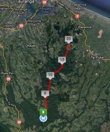
This sunny morning in October sees me off on the first of my 12 Trigs in 12 Months adventure.  The trig is an old friend, Otawa trig, reached from the intersection of Reid Road and Te Puke Quarry Road.  The first hour of today's journey I've run often, but today I'm planning to head right along the range to Otanewainuku, a challenge which has beckoned me since I first started exploring around Papamoa.  I think it's about 20kms, a really big run for me at my plodder's pace.  My map says the middle section is route marked only, meaning I'll have to keep my eyes peeled as I run.  The track is rough and uncleared in parts, great for twisted ankles.  There are numerous tracks leading off the main ridge, I might find myself back at the road.... but not at Otanewainuku.  It's hunting season, and I've meet the camouflage men with their rifles in the past.

The GPS is actually from Tom's phone on the return trip, I started from the North end and did the UPHILL leg.  


It's a run I've planned with my friend Clare, but now that I've come up with this daft 12 trigs plan, I'm impatient to get started, and she's away for the weekend.  There's also an element of Girl Vs Wild.  Can I follow the route?  Can I run that far?  Will I sprain an ankle?  Will I end up there all night?

As I was packing my bag the night before, Tom realised that I was going on my own.  He had presumed I was running with Clare, I don't think I had intentionally not updated him.......  I was excited.  He was concerned.  The sh*t hit the fan.  He's generally fairly low maintenance as far as husbands go, I mean, Clare and I ran at Summerhill Farm in the dark right through winter and he didn't even blink an eyelid.  But for some reason, this run through to Otanewainuku got his back up.  Well, the reasons apparently were that I don't know how to read a map, I've never been that route before, they're hunters routes not DOC tracks, I've not been running that far, the tracks are rough and I might sprain an ankle, I'd be on my own......  they were all fairly valid, except I was pretty offended when he said I couldn't read a map!  I've been practising at Summer Nav, and actually take the map reading job in some events since my map reader extraordinaire Manu is having a baby.  I mean, I often say I can't read a map, but I don't really mean it!

Anyway, after a whole lot of convincing, and a real fear that he might say I can't go, I convince him that the worst which happens is I end up at a different exit road and I'll run until I hit a farmhouse to ring him.  (and that's only if I don't have reception on my trusty $50 cellphone.)  I show him my bag with maps, compass, first aid kit, survival blanket, polyprops, goretex jacket and a gourmet picnic. We set up meeting times, back up plans, and back up back up plans. 

I hit the trail 7am the following morning, with heightened senses.  If I stuff this up, he'll say "I told you so".  And actually, as much as I've reassured him it's safe and I'm fine.... I'm really quite scared in the forest.  I know I can find my way out of this forest, just follow my nose for a day or two and it's not that big, I'll hit a road eventually.  It's the 'bad man' concept that worries me.  I have this idea that in the caves on the way to Otawa would be exactly the sort of place a homeless 'bad man' would live.  So, as I run, I'm listening to everything around me, becoming accustomed to the sounds of the forest.  The bushes sweep shut again behind me, and repeatedly I whirl around to see if the sound is someone following me.  I dislodge a broken branch and as it clatters behind me I think it is footsteps so I sprint 20 metres before looking.  I'm quite ridiculous I know.  I hope no one reads this blog.....

Suddenly I hear a sound which is definitely NOT natural.  It's metal on metal, definitely man made, really close, just a metre or two to my right.  It's amazing what you can think, feel and do in the space of milliseconds.  I'm imagining the 'bad man' coming for me, I hesitate and consider which way to go, my stomach clenches, and I do exactly what I've always planned NOT to do, I freeze.  The metal clinks again, and then four furry feet appear wrapped around a tree trunk right beside the track.  They shuffle up a metre, fall back down, the chain of the trap clinks again, and the trapped possum hides again behind the tree.  It takes a while for my heart rate to return to normal and head back off.

The track up to Otawa trig is just stunning and I never get sick of it.  I'm always amazed considering how close it is to the city, that more people don't walk and run there.  I very rarely see anyone, mostly just hunters, and I'm usually eating the cobwebs which spiders have spent all night making, meaning I'm the first person through in a while.  The native forest is like a scene from Lord of the Rings, all green and lush and mossy.  I have to concentrate pretty hard on where I put my feet, which is why I prefer to run off road, it takes my mind off my sore legs.  The trail has been cleared recently though, and some parts where previously I haven't been able to see where I put my feet are a bit quicker to move through now that  I can see the tree roots.

55 Minutes and I reach the first trig, stop for my first break, pleased with my time so far, although I know I can't keep it up.  I sit on the bars of the trig while I eat my muesli bar, text Tom to tell him I'm not lost yet, and look at my map just for fun, because I know where I am.  I completely miss the fact that my bum is pretty much sitting on a little sign taped to the trig which apparently said "Run Tui, Run! Run this way!"  Tom told me about it later in the day, he saw it on the downhill leg even though it was facing me as I ran up.  Terribly disappointed to have missed it, and  still haven't managed to go and collect it for my scrapbook.

Otawa trig by 8am.  Get used to my trusty 0.5mp phone photos. 


Two hours in I take another break, secure in the fact that I am in the middle of nowhere and haven't seen a soul all day.  A quick wee stop and I set up with my map and scroggin, only to have a fully camo'd hunter step out of the bushes and ask if I am lost.  No, I say, possibly slightly peevishly......  my instinct tells me he's not the 'bad man' even though his face is painted and he's carrying a rifle.  "Anyone else coming that way" he asks, pointing back the way I've run up.  "Yes, a couple more".  (I don't want him to know I'm on my own!)  So he heads off to stalk the deer which I apparently scared away with my big clompy footsteps.  I warn him I'll be coming past in ten minutes and please not to shoot me.

The route marked through the middle of the ridge is actually even better marked than the first leg, and I have no problems making my way through to Whataroa waterfall, which is so pretty it's a great excuse for my third stop of the day.

Whataroa waterfall, definitely a swimming hole to visit with the kids one day.

Shortly after, I hit the Rimu Loop walk at Otanewainuku.  Tom has texted to say that him and the girls are here already and are walking clockwise.  I turn anticlockwise to meet them, and have to run the loop twice before I catch them, turns out maybe he's not THAT much better at navigating than me anyway!  I've run through in 4 1/2 hours, including 3 ten minute rest stops.  My legs feel a bit achy for a few days, and I've got a raw part on my back where my hydra pack has been rubbing, a few scrapes and scratches but generally unscathed. 

Girl vs Wild.  Girl wins!